
The impact of the Upper Pripyat river deepening works on of Aquatic Warbler breeding habitats
Two steps closer to the identification of the Aquatic Warbler wintering sites
6 sierpnia 2008Wypalanie jako alternatywny sposób ochrony siedlisk?
5 września 2008The impact of the Upper Pripyat river deepening works on of Aquatic Warbler breeding habitats
The impact of the Upper Pripyat river deepening works on the hydrological regime of Aquatic Warbler breeding habitats.
More than 80 % of Ukrainian Aquatic Warblers breeds in Pripyat valley. Most of the territory is strictly protected by national and international legislation. Nevertheless, there is a serious threat for AW habitats in the Pripyat valley. The approved flood abatement program „Ecology-2010” in fact is a hidden draining of Pripyat floodplain and has already caused severe ecological damage.
Fig 1. Dynamic of water level at the monitoring plot „Pidgirya” and waterpost „Lyubyaz” in the Pripyat valley.
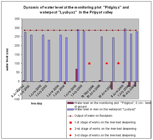
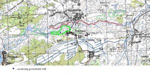
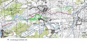
The first stage of Pripyat river-bed deepening was carried out in 2004-2005 between Schedrogir village (Pidgirya village) and Turiya river mouth. Near 5 km of river-bed were deepen (Map 1).In 2006 the bed deepening resulted in water level decrease in parts of the floodplain located in more than 1 km from the river, including for example haymaking fields near Krupyne lake and in opposite to low part of Pidgirya village. Sedge tussocks, among which there usually should be water, now are on the dry ground. There is no water in the floodplain for up 4 km downstream from the bridge, though this part of the river had always relatively high level of ground water. The level of water has become on 0,5-1,0 m below the ground. Despite the water-blocking influence of the bridge dam, the negative impact was shown in 2006 even for the upstream floodplain part in 1.5-2 km from the road Pidgirya-Schedrogir, where the monitoring plot is located (Fig.1).
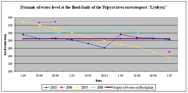
Fig 2. Dynamic of water level at the flood-lands of the Pripyat river on waterpost „Lyubyaz”
The second stage: in December 2006 the river bed was deepened for 2 km upstream from the bridge in Schedrogir village (Map 2). These works have strongly lowered a water level in the monitoring plot (Fig. 1). But this deepening of the river has not affected on breeding sites which are located upstream of the river (area of lake Strybuzh) due to a small height in the floodplain.
In 2007 the last stage of river-bed deepening was executed in this part of floodplain (Map 3). The deepening of river-bed was made on reach of channel, which crossed the height. As a result the level of water has dropped significantly (more than 0,5 m) in the sites of the floodplain including lake Strybuzh.
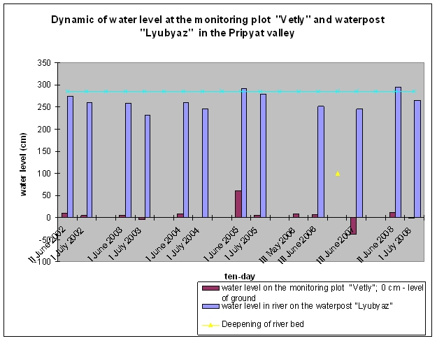
Fig 3. Dynamic of water level at the monitoring plot „Vetly” and waterpost „Lyubyaz” in the Pripyat valley
In May and June 2008 level of water in the Pripyat river floodplain was the highest for recent years (corresponding months) (Fig 2). The water table was high in the inter stream of Pripyat and Tsyr, in the mire “Zalissya”, in the parts of the floodplain to the west from Shlapan village, in the mire “Vizhery” in Turiya river valley. However, the deepening of the river caused a low water level in the floodplain between Richytsya village and Turiya river mouth (Fig 1).
The table shows the decrease of number of AW at the sites affected by river deepening works:
| Year | Breeding site | |||
| Pripyat valley between Retchica and Pidgirye (Shchedrogir) | Pripyat valley between Pidgirya and Turiya mouth | |||
| Monitoring plot
(28 ha) |
Total | Plot
(~20 ha) |
Total | |
| 2004 | 24 males | 300-350 males | 20 males | 120-150 |
| 2005 | 13 | 150-170 | 0 | 10-20 |
| 2006 | 20 | 240-270 | 10 | 40-60 |
| 2007 | 13 | 120-150 | 2 | 30-40 |
| 2008 | 13 | 80-100 | 2 | 15-20 |
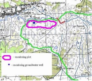
In 2006, there was also another river-bed part deepened downstream from Vetly village. The length of the dredged part is 1.5 km. This was enough to substantially lower the water level in the nearby floodplain, including the monitoring site (Map 4). In 2007 the water level there was the lowest since 1995. In 2008 hydrological conditions were optimal (the season was very rainy). Nevertheless deepening works have lowered the level of water in monitoring plot on 10-30 cm (Fig.3).
The number of AW at these sites in 2008 was very low in spite of abundant precipitations. Estimates of USPB, BirdLife International partner in Ukraine, show that consequences of the Pripyat floodplain drainage threat more than 1,000 males. Therefore, urgent actions are needed to prevent harmful effects of planned and ongoing hydrotechnical activities.
A group of experts, including the representatives of RSPB, APB-BirdLife Belarus, USPB and Michael Succow Foundation carried out a site visit. As a result a plan of urgent actions has been developed. USPB has launched a lobby campaign to stop such projects; and more survey data is needed to justify the lobby and conduct it effectively.
Please, read also USPB AW monitoring report 2007.
For more information contact: Anatoly Poluda, USPB
polud@izan.kiev.ua